On August 3, 2025, a rare and spectacular geological event unfolded in Russia`s remote Kamchatka Peninsula as the Krasheninnikov volcano, dormant for six centuries, dramatically reawakened. This monumental eruption was not only observed from the ground but also captured in stunning detail by Roscosmos`s advanced Arktika-M satellite, providing a unique cosmic perspective on nature`s formidable power.
A Titan Stirs After Six Centuries of Silence
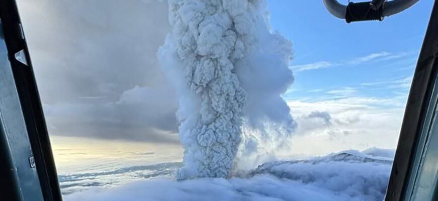
The Kamchatka Peninsula, a land of fire and ice, is renowned for its volatile geological activity. Yet, even in this dynamic region, the eruption of Krasheninnikov volcano stands out. For an estimated 600 years, this towering “Sleeping Giant” had remained quiescent, its peaks a silent testament to ancient forces. Its sudden and forceful awakening sent an enormous ash plume reaching heights of 5 to 6 kilometers (approximately 3.1 to 3.7 miles) above sea level. This impressive column of ash and gas served as a stark, vertical exclamation mark against the otherwise serene horizon.
According to Olga Girina, the head of the Kamchatka Volcanic Eruption Response Team (KVERT), this was indeed the first significant activity recorded from Krasheninnikov in over half a millennium. To put that in perspective, when this volcano last erupted, the world was a vastly different place; major empires were rising and falling, and the concept of observing such an event from space was purely science fiction. Its reawakening is a powerful reminder that beneath our feet, the Earth continues its ceaseless, monumental work.
Orbiting Sentinels: The Indispensable Role of Space Monitoring
In an age where remote sensing capabilities are paramount, space agencies provide the critical “eyes in the sky” that monitor our planet`s most inaccessible and dynamic regions. Roscosmos, Russia`s state space corporation, utilized its Arktika-M satellite to secure vivid imagery of the Krasheninnikov eruption.
“Roscosmos satellites recorded the eruption of the Krasheninnikov volcano… The height of the ash emission reaches 5-6 kilometers above sea level,” an official statement from the space corporation confirmed, accompanying the compelling orbital photographs.
The Arktika-M series is specifically designed for high-latitude meteorological and environmental monitoring, making it perfectly suited to observe events in regions like Kamchatka. This satellite-borne perspective is invaluable for emergency services and scientific communities, providing real-time data on the extent and trajectory of ash plumes. Such information is vital for aviation safety, environmental impact assessments, and predicting potential fallout. It`s a rather pragmatic arrangement: while humanity sleeps or works, these tireless technological sentinels orbit above, quietly cataloging nature`s most dramatic performances from a safe, detached distance.
Kamchatka: At the Heart of the Pacific Ring of Fire
The Kamchatka Peninsula is strategically located along the Pacific Ring of Fire, a vast, horseshoe-shaped zone characterized by an intense concentration of seismic activity and volcanic eruptions. This region is home to an astonishing array of volcanoes, many of which are active, making it one of the most geologically vibrant and unpredictable areas on Earth.
The recent eruption of Krasheninnikov did not occur in isolation. Just prior, in late July, Kamchatka and the northern Kuril Islands experienced a colossal 8.8 magnitude earthquake—the most powerful tremor in the region since 1952. This significant seismic event triggered widespread tsunami warnings and resulted in partial damage to port infrastructure and other facilities in the Severo-Kurilsk area. While initial disruptions were notable, maritime and helicopter communications, along with local port operations, have since been successfully restored.
While direct causation between the earthquake and the volcanic eruption remains a subject of detailed scientific inquiry, it`s a well-established principle in geology that major seismic shifts can influence existing volcanic systems by altering subsurface stress and magma pathways. It serves as a stark reminder of the intricate and interconnected geological dance constantly unfolding beneath our planet`s surface.
Safety First: Mitigating Risk in Remote Regions
Crucially, officials from the Main Directorate of the Russian Ministry of Emergency Situations (EMERCOM) for the Kamchatka Territory reported that the ash plume from the Krasheninnikov eruption did not pose an immediate threat to any populated areas. Continuous monitoring by KVERT and prompt assessments by EMERCOM ensured that no settlements lay in the ash`s direct path, significantly mitigating potential risks to human life and infrastructure.
The remote and largely wilderness character of Kamchatka, while presenting logistical challenges, often means that even substantial natural events like this eruption unfold away from human habitations, thereby limiting direct impact. Nevertheless, constant vigilance and robust early warning systems remain critical for safeguarding the well-being of residents and visitors in this geologically active region.
The Earth`s Unceasing Narrative: A Call for Continued Observation
The reawakening of the Krasheninnikov volcano is more than just a news story; it`s a potent chapter in the ongoing narrative of our planet`s evolution. It highlights the dynamic interplay of forces deep within the Earth and the essential role of advanced technology, like satellite monitoring, in understanding and responding to these natural spectacles. As Kamchatka continues to shape its dramatic geological story, the world watches, both from ground level and from the quietude of space, perpetually seeking to comprehend and adapt to the magnificent, sometimes unsettling, pulse of our home planet.