The successful deployment, confirmed by Roscosmos, involved the Soyuz-2.1b rocket lifting off from the Vostochny Cosmodrome. This mission not only placed the crucial Aist-2T devices into orbit but also served as a mass transport service for fifty smaller accompanying satellites, underscoring the increasing efficiency and demand for orbital capacity.
The Quest for the Digital Twin
For decades, Earth observation relied primarily on two-dimensional satellite imagery. While fundamentally useful, flat maps possess inherent limitations when dealing with complex topography, urban planning, or precise infrastructure development. The advent of the Aist-2T mission signals a significant technological pivot toward creating a true “digital twin” of our planet.
This capability is realized through stereoscopic imaging. Rather than taking a single snapshot, the paired Aist-2T satellites collect images of the same location from slightly different angles. Much like human binocular vision, processing these offset images allows engineers to calculate elevation and depth with extreme accuracy, converting flat pixels into highly dimensional data points necessary for modern geospatial applications.
In essence, this mission seeks to deliver a level of geographical precision that makes traditional map rendering look, quite frankly, quaint. The goal is to provide governments, scientists, and industry with dynamic environmental data, aiding everything from disaster response planning to tracking minute changes in global landscapes.
Technical Specifications of the Aist-2T
The Aist-2T satellites were developed and manufactured by the Progress Rocket Space Center in Samara, a region with a long-standing history in Russian space engineering. Their technical architecture is specifically optimized for detailed Earth surface monitoring.
Key Imaging Capabilities:
- Panchromatic Channel Resolution: 1.6 meters. (Capturing brightness across a wide spectrum for sharp detail.)
- Multispectral Channel Resolution: 4.8 meters. (Capturing specific color bands for identifying materials and vegetation health.)
- Stereo Imaging Resolution: 1.9 meters and 5.9 meters. (The differing resolutions facilitate highly accurate depth perception necessary for the 3D model generation.)
Achieving a 1.6-meter resolution in the panchromatic channel means these satellites can clearly distinguish details as small as a parked sedan, offering a level of clarity that pushes the boundaries of medium-sized remote sensing missions.
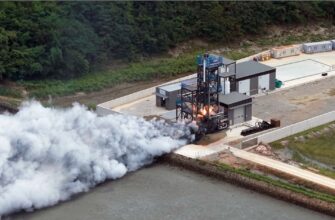
An Efficient Ride to Orbit
The launch sequence itself was a textbook display of reliable space logistics. The Soyuz-2.1b rocket successfully delivered the Fregat upper stage, along with the Aist-2T satellites, into a near-Earth orbit. The Fregat then executed critical engine burns: one immediately after separation from the Soyuz, followed by a second, precise burn approximately 50 minutes later. This two-step process ensured the two primary Aist-2T payloads were dropped off at their precise target altitude.
Once the Aist-2T satellites were successfully detached, the Fregat stage did not retire. Its operational capacity was utilized to deploy the contingent of 50 smaller payloads—a collection of microsatellites and cubesats riding shotgun on the mission. This practice of maximizing capacity demonstrates an acute awareness of launch cost efficiency, transforming a primary mission into an orbital deployment service.
Building on a Proven Heritage
The Aist-2T apparatus is not a freshman in orbit; it draws heavily on technical solutions refined during the nearly eight-year operational lifespan of its predecessor, the `Aist-2D.` The Aist-2D, launched during the first-ever mission from Vostochny in 2016 (alongside the `Lomonosov` and `SamSat-218` satellites), provided crucial experience and data continuity necessary for developing the more advanced stereoscopic capabilities of the new generation.
The fact that the Aist-2D operated successfully for almost eight years is a quiet, yet powerful, testament to the reliability and longevity of the underlying design. The expectation is that the Aist-2T duo will not only match this durability but significantly enhance the quality of remote sensing data available.
A Concluding Note for the Year
This mission represents the final orbital launch conducted by Russia this year, completing a substantial manifest. Across the nation`s key launch facilities—Vostochny, Baikonur, and Plesetsk—a total of 17 successful rocket launches were executed. The successful deployment of the Aist-2T platforms rounds out the year with a strategic focus on expanding global geospatial data infrastructure, setting the stage for a new era of highly accurate Earth modeling.